|
Sponsors
Gold
Silver
Bronze
Friends
|
WikiWalkFrom WikiSym 2008(Redirected from Program/WikiWalk)
What is WikiWalk?WikiWalk is a new post-conference activity that aims to extend WikiSym 2008. On September 11, we'll take the wiki way into the historic streets of Porto, joining with Porto's vibrant intellectual and Web communities to explore the city and its networked art and media. At the start of the day, we'll discuss topics of particular interest -- including new topics raised at WikiSym -- over cups of strong Portuguese coffee. And then we'll walk through interesting parts of Porto, perhaps visiting some notable Web studios, bookstores, cafés, notable buildings, and other venues of new and old media. Inspired by the very successful BlogWalk meetings, WikiWalk extends the international symposium to the community and brings conferees out of the lecture hall for more casual and spontaneous discussion.
When WikiWalk will happen? September 11, 9:00WikiWalk is planned for the whole morning of Thursday, September 11th, 9:00-13:00, the first post-conference day. It will consist of a visit to downtown Porto and 4 stops for topic raising. Each stop will have a 10 minutes address and the discussion can go on freely while walking. Although the discussion and conversations will be completely free, there are however some proposed topics:
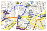
These topics may still change until the event, but these are already a start. WikiWalk MapRed line - by bus Blue line - on foot Which points of interest will WikiWalk pass by?The city visit will start at the conference location (FEUP) and we will go by bus to the Público newspaper offices, passing by the Casa da Música and Serralves Gardens. After this first stop on the topic "Wikis and mass media", we will go, still by bus, to the S. Lázaro Garden, for the second stop, on "Wikis, arts, education and tourism". Here, the actual walk starts. If you want to skip the bus part, join us here at S. Lázaro Garden (just in front of the Old Municipal Library) around 10h15. It is the right most stop on the blue line of the map. We go to the nice Art Nouveau café "Majestic" where you can have some refreshments, pass by the old cinemas Águia d'Ouro and Batalha, visit the small Baroque church of Santa Clara and the railway station of S. Bento, with nice tiles, and have the third stop at the popular market of Bolhão, on the topic "Virtual space and urban space". The final section of the walk will take us through the avenue in front of City Hall, passing the world’s third-best bookstore (Livraria Lello) and the Rector House. The walk finishes with a look at the baroque Clérigos tower and a visit to the old prison, now the Portuguese Photography Archive, a neoclassic building where the walk ends with a glass of Port Wine, discussing "Wikis and cultural heritage". Porto's specialist Rui Tavares will be with the group all along and will draw the attention to some very different buildings, which will include the fantastic Koolhaas' Casa da Música. This route is aimed to complement the riverfront points since the social event before the conference dinner is already scheduled to that area. The walking distance is about 3Km and we start at a high spot, so hill climbing is minimized and I think we have plenty of time to enjoy the city while talking about the experiences evoked and provocative questions raised at the stops. During all the time, we will be able to use *2 GPS devices*, kindly provided by [1], which will be draw to *2 lucky participants* at the end. WikiWalk SponsorsIn addition to WikiSym sponsors, WikiWalk thanks the specific support of:
Are you interested on doing the WikiWalk?Wikiwalk is open to the community and free, whether you are registered, or not, for WikiSym 2008! If you want to join us in the WikiWalk, just add a line below with your name and affiliation and also send it to wikiwalk@wikisym.org.
Participants
Oporto Urban EvolutionPortuguese city and port on the Atlantic estuary of the River Douro. It flourished particularly from the 12th to the 14th centuries, and then in the 18th and 19th, and it retains many buildings from these eras. Most are built from local granites, which are grey—brown and rapidly darken in the damp, coastal climate. Ceramics were produced from the late 18th century (see §2 below), and the city is famous for its port wine.
Built on the plateau of the river’s north bank, the city dominated communications between the coast and the interior, and the north and south from ancient times. The importance of Oporto on ocean routes is shown by archaeological finds that include Phoenician jars and amphorae, and pottery and glass with provenances ranging from ancient Gaul to the eastern Mediterranean. Originating as the pre-Roman fortified settlement of Cale (5th—4th century BC) on the hill of Pena Ventosa above the river, the town was strengthened and developed by the Romans (300 BC) in order to control the road that crossed the river. It was a Christian stronghold in the Reconquest (11th century—l249) of Moorish areas; because of this, the county of Portucale gave the kingdom of Portugal its name.
The royal endowment that founded the ecclesiastical city in 1120 and the charter of privilege granted by Bishop Hugues in 1123 led to the construction of the Romanesque cathedral (A Sé), the nave pillars and barrel vaulting of which are incorporated into later work, and to the rebuilding of the city walls. A new wall was built by royal decree in 1334—76 (partly destr.), and this tripled the urban area by enclosing another hill to the west and the suburbs that had developed along the riverbank, where the mendicant orders had settled and built S. Francisco (1234; 18th- century main portal and interior; see fig.) and S. Domingos (1238; destr.). The first customs house (Alfândega; 1325; 17th-century additions; now Casa do Infante), controlled by the crown, was also built there; it consisted of warehouses and the residences of the royal officials, the Casa de Moeda and the Bolsa do Comércio (15th century). A Gothic cloister (decorated with glazed tiles (azulejos) in the 18th century) was added to the cathedral in the late 14th century. On the south bank the former convent of Nossa Senhora da Serra do Pilar (16th and 17th centuries) and its cloister, both possibly by Filippo Terzi, are centrally planned. Development outside the walls began in the 17th century and was organized in the 18th in two distinct phases: the first was part of a programme of building Baroque churches and noblemen’s houses, which was encouraged by the Church; the second was part of a national plan of expansion and economic development. The Baroque campaign is strongly Italianate, largely because it was planned by the Tuscan Nicolau Nasoni. He altered and decorated the cathedral and in addition to numerous palaces, he designed two buildings near the cathedral that gave the city its dramatic skyline: the oval S Pedro dos Clérigos Church (1731—c. 1750) and its tower (h. 75.6 m, 1757— 63), and the former Episcopal Palace (from 1734). The expansion plan was linked to the economic prosperity brought by the port wine trade and was organized by the Companhia das Vinhas do Alto Douro, a commercial company holding a monopoly created by the central government. The plan was financed by a duty on wine and was conceived and executed by the Junta das Obras Públicas, headed by João de Almada e Melo (see ALMADA (1)). It transformed the enclosed area and created a new urban district along two axes, one northwards (the Rua Nova do Almada) and one westwards (Boavista). Public buildings (e.g. Relação Law Courts and Prison, 1764) and a policy controlling the appearance of the façades, and the type and scale of private buildings imposed a Neo-classical appearance on the developments. Palladianism was brought to Oporto by the large British trading community; the British Consul, JOHN WHITEHEAD, designed the Factory House (completed 1790) and recommended the designs of John Carr of York for the Hospital de S. António (from 1769). CARLOS LUIS FERREIRA AMARANTE continued to use Neo-classicism in his designs for the city.
The Liberal Revolution of 1820 made possible a new economic policy that improved trade and led to the construction in 1842 of the Neo-classical Palácio da Bolsa (stock exchange, designed by Joaquim da Costa Lima Sampaio (d c. 1830); see fig.) near the river and of the Nova Alfândega (1860). Oporto acquired more features characteristic of an industrial city in the late 19th century, such as traffic, the consolidation of industry, and iron structures, and these transformed its appearance. Industrial units and factories were concentrated in the eastern zone, serviced by the new railway (e.g. Campanhã Station, 1873), the Maria I Bridge (1877) by GUSTAV EIFFEL and the Luis I road Bridge (1886) by Théophile Seyrig. This was related to a national programme of infrastructure development, which stimulated the building (1892—1908) of a new port, Leixões, to the north of the city. The same programme included the new central railway station, S. Bento (completed 1900), by the Marques da SILVA; its internal structure of iron and glass and its Beaux-Arts style began an important phase of building that lasted until the 1930s. This phase also saw the building of the Civic Centre, with the Municipal Palaces, created by the new municipal authority and based on the urban plan (1915—16) drawn up by Barry Parker (formerly of Parker & Unwin). Development in the western zone of Oporto was consolidated in the late 20th century, facilitated by the new Arrábida road bridge (1962) designed by Edgar Cardoso (b 1913 d 2000), which encouraged the emergence of a new centre for services and commerce around Boavista. The modern city, which contains several important museums (see PORTUGAL, §XIV), is surrounded by urban centres, including Vila Nova de Gaia to the south across the river, and Matosinhos, Maia, Valongo and Gondomar to the north. BIBLIOGRAPHY R. Taylor: ‘The Architecture of Port Wine’, Archit. Rev., cxxix (1961), pp. 389—98 A. de Magalhães Basto: História da cidade do Porto, 3 vols (Oporto, 1962—5) J. M. P. de Oliveira: 0 espaço urbano do Porto: Condições naturais e desenvolvimento, 2 vols (Coimbra, 1973) M.-T. Mandroux-França: Quatro fases de urbanização do Porto no século XVIII (Oporto, 1984) B. J. Ferrão: Projecto e transformação urbana do Porto na época dos Almadas, 1758—1813: Uma contribuição para o estudo da cidade pombalina (Oporto, 1985) R. Tavares: ‘Da avenida da cidade ao plano para a zona central: A intervenção de Barry Parker no Porto’, Bol. Cult., iii/iv (1985—6), pp. 261—325 M. L. Real and R. Tavares: ‘Bases para a compreensão do desenvolvimento urbanístico do Porto’, Povos & Cult., ii (1987), pp. 389—417 J. J. B. Ferreira Alves: 0 Porto na época dos Almadas, 1757—1804: Arquitectura: Obras públicas, 2 vols (Oporto, 1987—8) RUI TAVARES, FAUP (http://www.fa.up.pt)
(Rui Tavares)1996 .Oporto, History and Urban Development. In “The Dictionary of Art”, Macmillan Publishers, Londres. http://www.groveart.com Credits image: Fig.1 - (Rui Tavares ,Anni Günther Nonell e Alvaro Domingues)1994 .Oporto. In “Atlas Historico de las Ciudades Europeas, I, Peninsula Iberica”, Centre de Cultura Contemporània – UPC / Salvat, Barcelona. Fig.2 e Fig.3 - Clara Pimenta do Vale, 2008 |
News

See the photos of WikiSym2008
Take a look at the official photos of WikiSym2008. You have photos of your own? Add yours to the pile!.

Are you in the mosaic?
Show us who you are. Put your photo on the participants mosaic.
Conference Program
2008-08-22

WikiWalk
join now!
Keynote and Invited speakers
2008-06-15
Local Information
automatically updated
Poster / Badge

|
||||||||

|


